
Dingri, a Tibetan term meaning "Sound Hill," is situated in the southern part of the Tibet Autonomous Region, at the northern base of the central Himalayas. It is a border county of the region, neighbouring Lhazi, Sakya, and Dingjie Counties to the east, the Kingdom of Nepal to the south, Nyalam County to the west, and Angren County to the north.
In June 1960, the county was established in Ganggar (now known as "Old Dingri"). It has a length of 115 kilometres from east to west, a width of 152 kilometres from north to south, and covers an area of 14,049 square kilometres. It currently governs 182 village committees in 2 towns and 11 townships, with a population of nearly 70,000. In July 1968, it relocated to its current location in Shegar Town, known as "New Dingri" by the locals.
Geography
Tingri County in the Himalayan region is an enchanting alpine landform with diverse terrains. Mount Everest reigns over the high mountainous area, attracting adventurers. The Pengqu Valley offers a serene ambience with lush greenery and stunning views. Laguigangri is a mysterious mountainous area with hidden valleys and deep gorges. Doyala-Langmula presents rugged terrain for rock climbers. Tingri County showcases the beauty and power of nature, offering unforgettable experiences for adventurers.
Weather
This region has a semi-arid climate with long sunny days and significant temperature variations. It receives little rainfall, resulting in a dry atmosphere and arid conditions. The ample sunshine promotes outdoor activities and boosts mood and well-being. A frost-free period allows for diverse crop cultivation. The cool temperatures provide relief from extreme heat. However, the region is prone to natural disasters such as drought, frost, wind and sandstorms, and insect infestations. The inhabitants adapt through innovative practices and protection measures. Overall, the region's unique climate shapes its environment and daily life, presenting challenges but also opportunities for growth and resilience.
Agriculture
Tingri, in Tibet, is a captivating county blending agricultural and pastoral traditions. With vast farmland, it nurtures crops like barley, wheat, and peas for sustenance and prosperity. The stunning grassland is a grazing ground for animals like yaks and horses, creating a bond with the locals. Tingri's famous products include silver waist buttons, representing cultural pride, and silver bowls, adding elegance to dining. Pottery pots showcase traditional craftsmanship and rustic charm. Tingri offers a chance to explore Tibet's essence and create an enchanting experience for visitors.
Natural Mineral Resources
Mineral resources comprise lead, zinc, antimony, tungsten, coal, graphite, crystal, and muscovite. Wildlife consists of snow leopards, Himalayan musk deer, Himalayan tahr sheep, leopard cats, red pandas, and Tibetan wild donkeys.
Additionally, valuable medicinal substances include Cordyceps, Angelica, Astragalus, Huhuanglian, Snow Lotus, Ephedra, Codonopsis, Gastrodia elata, and Panax ginseng.
Transportation
All 21 towns in Tingri County have road access, with 60% of villages having cars. The China-Nepal Highway passes through, heading east to Lhasa (684 km). Xieger Town is 7 km from National Highway 318 and 75 km from Lazi. Xieger is 11 km west of the intersection to Mount Everest, 49 km west of Laodingri, 100 km west of the Lalongla Pass (5,050 meters), and 53 km west of Nyalam.
Famous attractions in Dingri
Rongbuk Monastery
The Rongbuk Monastery, constructed in 1899, is the world's highest temple. Situated at the terminus of the Rongbuk Glacier, at an elevation of 5154 meters, it lies approximately 20 kilometres from the summit of Mount Everest. Serving as the base camp for ascending Mount Everest from the northern slope, it offers a splendid vantage point to observe and capture photographs of the majestic peak.
Xiegel Qude Temple was constructed in 1385. The temple comprises 15 halls, primarily devoted to a majestic gilded bronze statue of Sakyamuni, standing at a height of 9 meters. It adheres to the Gelug sect and has been served by 28 Khenpos consecutively. In 1985, the temple underwent a renovation, resulting in the current configuration of 4 halls, with the prominent centrepiece being the Hand-held Vajra Buddha.
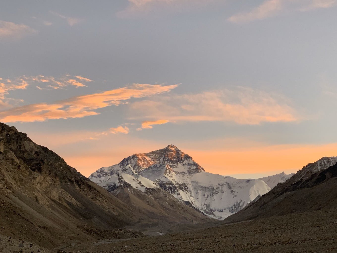
Mount Everest
"Mount Qomolangma," meaning "Holy Mother" in Tibetan, is the highest peak in the world, with an altitude of 8848 meters. Its summit is perpetually covered in snow, creating a sacred spectacle. The Mount Everest region boasts 4 peaks surpassing 8,000 meters and 38 peaks exceeding 7,000 meters, establishing it as the third-tier region on the planet.
Mount Cho Oyu
Located on the Sino-Nepalese border, Cho Oyu Peak, meaning "chief respected teacher" in Tibetan, stands at an altitude of 8201 meters, making it the sixth-highest peak globally. Situated approximately 100 kilometres east of Mount Everest, it features five ridges adorned with numerous glaciers. Notably, the Austrian mountaineering team achieved the first ascent of Cho Oyu on October 19, 1954.
Ziburi Sacred Mountain, also known as Feilai Mountain, is a 5,500-meter-high peak believed to have originated from India. The mountain boasts 108 temples, springs, and karst caves, making it a revered site among the locals. Additionally, it is home to a significant collection of insect fossils that hold immense scientific importance.
Gawula Mountain Pass
Gawula Mountain Pass is situated in Zhaxi Zongxiang, at an elevation of 5,200 meters. It serves as a renowned vantage point for capturing Mount Everest. From the mountain's summit, one can behold a majestic panorama of rolling mountains below. In the far distance, the Himalayas boast four peaks, namely Makalu, Lhotse, Everest, and Cho Oyu, all-surpassing an impressive altitude of 8,000 meters. Their grandeur is truly awe-inspiring.
Rongjugou is situated in Rongjia Township, one of the six primary ditches in Shigatse, spanning approximately 55 kilometres. It is a landform characterized by tall mountains and deep valleys carved by faults on the southern slope of the Himalayas. The altitudes in this area vary from 7,340 meters to 2,100 meters, encompassing diverse landscape types from frigid to subtropical. Rongjugou holds significance as the final resting place of Milarepa, a Tibetan Buddhist ascetic monk.
Gama Valley
Gama Valley is renowned as "the most beautiful valley worldwide". It is distinguished by its dense forests, vibrant rhododendrons, pristine springs and streams, profound canyons, and colourful avian species. The valley offers a breathtaking view of Mount Everest, Lhotse, and Makalu.
Rongbuk Valley
Rongbuk Valley is a plain formed by the Rongbuk River resulting from the melting of the Rongbuk Glacier under Mount Everest. It has an average altitude of 4,000 meters. The valley features expansive green fields and villages surrounded by lush trees. The mountain section along the river valley displays prominent extrusion folds, providing visible evidence of the historical transformations of the Qinghai-Tibet Plateau.
https://tourtraveltibet.com/discover-the-enchanting-beauty-of-tingri-geography-climate-culture-and-attractions/


0 Comments